License Management
IFS records the usage of the IFS Cloud application.
License Metrics
Using predefined metric calculation methods, calculate the usage of IFS Cloud application per installation. These methods execute monthly basis. Along with the metrics generation, a report will be generated and archived for the reference.
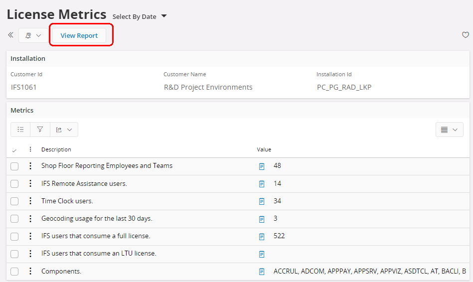
Metrics
Visibility of metric is based on the availability of corresponding module.
| Metric | Description | Module |
|---|---|---|
| GEOCODE_TRANSACTIONS | Geocoding usage for the last 30 days. | APPSRV |
| LTU_IFS_USERS | IFS users that consume an LTU license. | FNDBAS |
| FULL_IFS_USERS | IFS users that consume a full license. | FNDBAS |
| IFS_SERVICE_ACCOUNT_USERS | IFS service account users. | FNDBAS |
| IFS_SYSTEM_USERS | IFS system users. | FNDBAS |
| FNDREM_ACTIVE_USERS | IFS Remote Assistance users. | FNDREM |
| SERVICE_ENG_APP | All active Service Engineer App users. | MWO |
| MAINT_ENG_APP | All active Maint Engineer App users. | MWO |
| NOTIFY_ME | All active NotifyMe users. | NTFYME |
| SHOP_FLOOR_USERS | Shop Floor Reporting Employees and Teams | SHPORD |
| TIMCLO_ACTIVE_USERS | Time Clock users. | TIMCLO |
| SCAN_IT | All active Warehouse Data Collection Cloud Web users. | WADACO |
| EXPENSE_ML_USAGE | Machine learning usage in Expense Reporting for the last 30 days. | TRVEXP |
| SITES | Number of Sites. | MPCCOM |
| EQUIPMENT_OBJECTS | Number of Equipment Objects. | EQUIP |
| FUNCTIONAL_OBJECTS | Number of Functional Equipment Objects. | EQUIP |
| ACTIVE_PROJECTS | Number of Projects that are not Closed or Cancelled. | PROJ |
| WORK_ORDERS | Number of completed Work Orders, that is, Work Orders in status Finished or Reported. | WO |
| ALL_WORK_ORDERS | Number of Work Orders, regardless of status. | WO |
| WORK_ORDER_TASKS | Number of Work Order Tasks that are not Cancelled. | WO |
| WORK_TASK_ASSIGNMENTS | Number of Work Task Assignments that are not Cancelled. | WRKTSK |
| VEHICLES | Number of Serials belonging to Template Parts that are not used as a sub-assembly. Used to meter Vehicles and Rolling Stock. | VIM |
GEOCODE_TRANSACTIONS
This metric tracks geocoding usage for the last 30 days. Gecoding is the process of transforming an address or place description into a lat/long coordinate. This is for example used from the Retrieve Map Positions in the Location Addresses screen. If the REQMGT (Request Management) component is active, and once a customer visit address is created (which can be done in various ways), a location is created and a map position is created using the geocoding functionality.
Read more about Geocoding